


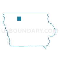
BOOTH TWP Voting District, Palo Alto County, Iowa
About
Outline

Summary
| Unique Area Identifier | 583000 |
| Name | BOOTH TWP Voting District |
| County | Palo Alto County |
| State | Iowa |
| Area (square miles) | 35.24 |
| Land Area (square miles) | 34.55 |
| Water Area (square miles) | 0.69 |
| % of Land Area | 98.04 |
| % of Water Area | 1.96 |
| Latitude of the Internal Point | 42.95129950 |
| Longtitude of the Internal Point | -94.85389730 |
Maps


Graphs
Select a template below for downloading or customizing gragh for BOOTH TWP Voting District, Palo Alto County, Iowa


Neighbors
Neighoring Voting District (by Name) Neighboring Voting District on the Map
- CUMMINS TWP Voting District, Pocahontas County, IA
- GARFIELD TWP Voting District, Clay County, IA
- GREAT OAK TWP Voting District, Palo Alto County, IA
- LOGAN TWP W/O GILLETT GROVE Voting District, Clay County, IA
- POLAND TWP Voting District, Buena Vista County, IA
- RUSH LAKE TWP W/O MALLARD Voting District, Palo Alto County, IA
- SILVER LAKE TWP Voting District, Palo Alto County, IA
- SWAN LAKE TWP Voting District, Pocahontas County, IA
Top 10 Neighboring County Subdivision (by Population) Neighboring County Subdivision on the Map
- Swan Lake township, Pocahontas County, IA (1,448)
- Rush Lake township, Palo Alto County, IA (466)
- Poland township, Buena Vista County, IA (442)
- Silver Lake township, Palo Alto County, IA (304)
- Cummins township, Pocahontas County, IA (263)
- Garfield township, Clay County, IA (261)
- Logan township, Clay County, IA (156)
- Great Oak township, Palo Alto County, IA (148)
- Booth township, Palo Alto County, IA (90)
Top 10 Neighboring Unified School District (by Population) Neighboring Unified School District on the Map
- Emmetsburg Community School District, IA (4,991)
- Laurens-Marathon Community School District, IA (2,114)
- West Bend-Mallard Community School District, IA (2,020)
- Ruthven-Ayrshire Community School District, IA (1,548)
- South Clay Community School District, IA (910)
Top 10 Neighboring State Legislative District Lower Chamber (by Population) Neighboring State Legislative District Lower Chamber on the Map
- State House District 52, IA (28,211)
- State House District 5, IA (27,563)
- State House District 8, IA (26,866)
- State House District 7, IA (26,716)
Top 10 Neighboring State Legislative District Upper Chamber (by Population) Neighboring State Legislative District Upper Chamber on the Map
- State Senate District 3, IA (56,697)
- State Senate District 26, IA (55,929)
- State Senate District 4, IA (53,582)
Top 10 Neighboring 111th Congressional District (by Population) Neighboring 111th Congressional District on the Map
Top 10 Neighboring Census Tract (by Population) Neighboring Census Tract on the Map
- Census Tract 801, Clay County, IA (2,064)
- Census Tract 7801, Pocahontas County, IA (1,972)
- Census Tract 9602, Palo Alto County, IA (1,813)
- Census Tract 9604, Palo Alto County, IA (1,640)
- Census Tract 9601, Buena Vista County, IA (1,570)